Slieve League Cliffs
Slieve League Cliffs
Slieve League Cliffs, near Carrick in Donegal, tower nearly 600 metres above the Atlantic Ocean: practical guide to prepare your visit.
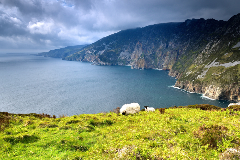
The Slieve League Cliffs (Sliabh Liag in Irish) rise nearly 600 metres above the Atlantic Ocean in the south-west of County Donegal. Almost three times higher than the Cliffs of Moher, they rank among Europe's most imposing sea cliffs and constitute one of the flagship stops on the Wild Atlantic Way. The site is reached from the village of Carrick, approximately 1.5 hours' drive from Donegal town.
Why visit Slieve League Cliffs
Slieve League combines several attractions rarely found on a single site. The sheer height of the rock faces, their ochre hue tinged with red depending on the light, and views stretching across Donegal Bay, the Sligo Mountains and Bendbulben Mountain on clear days offer one of the most expansive panoramas in north-west Ireland.
The location remains considerably less crowded than the Cliffs of Moher: you'll encounter hikers rather than tour buses, and the trails allow you to distance yourself quickly from the main car park. Add to this layers of successive history — a paleo-Christian monastic site, military remains from the nineteenth and twentieth centuries — that give the place a depth extending far beyond a simple viewpoint.
History of the site
Slieve League became a Christian pilgrimage destination in the earliest centuries. The remains of a paleo-Christian monastic site survive on the mountainside, with stone beehive huts and the remains of a chapel, testifying to the passage of monks before Ireland's full Christianisation.
In the early nineteenth century, the British constructed a signalling tower at Carrigan Head, dating from the Napoleonic Wars. It served to monitor a possible French assault along the Atlantic coast.
The most singular episode dates to the Second World War. Although Ireland was officially neutral, the country reached discreet agreements with the Allies around what became known as the "Donegal Corridor": Allied aircraft were permitted to cross this portion of territory from the Enniskillen base in Northern Ireland to reach the Atlantic. To orient pilots, the word Éire was traced in large stone letters across several promontories in Donegal. One of these inscriptions remains visible not far from the Slieve League viewpoint car park.
What to see and do
The main viewpoint
The most accessible overlook is found at Bunglass. A car park allows you to stop and reach the first platform in just a few minutes' walk. From here you best grasp the scale of the rock faces and the vertiginous drop to the sea.
The hike to the summit and One Man's Pass
To reach the highest point, a trail climbs gradually along the ridge. The final section, called One Man's Pass, is a narrow, unprotected arête, exposed to wind. It is suitable only for experienced hikers and should only be attempted in stable weather. Casual visitors are well advised to stop at the viewpoint or at an intermediate point, which is already spectacular.
The monastic site and Carrigan Head tower
On the slopes, by venturing off the main trail, you can still make out the remains of the beehive huts and chapel. The Napoleonic tower at Carrigan Head, below the main site, completes the historical narrative of the place.
Slieve League from the sea
Several operators offer boat excursions from Teelin and Killybegs. Viewed from below, the rock face takes on a different dimension: you can see the rock formation nicknamed the "Giants Desk and Chair" at the base of the cliffs, invisible from the top. Dolphins and basking sharks frequent these waters, especially in summer.
Slieve League Cliffs Centre
On the road leading to the site, the Slieve League Cliffs Centre houses a craft shop (knitwear, local woolens), a café and an information point. Traditional music sessions are organised there during the summer season.
Practical information
- Vehicle access: a narrow, winding road leads to the Bunglass car park, located past a gate you may need to open yourself. Cautious driving is recommended.
- Foot access: it is possible to leave your car at the lower car park and walk up (allow a good hour), a more contemplative option.
- Equipment: walking shoes, waterproof windbreaker, warm layers even in summer. Wind can be violent at cliff edge.
- Safety: no barriers along most of the summit trail. Keep children away from edges, do not approach in gusts, turn back if visibility drops.
- Duration of visit: allow 1-2 hours for the viewpoint, 4-5 hours to reach the summit and return.
- Fee: free access to the site.
When to visit
The most favourable period runs from May to September: long days, more stable weather, and seasonal presence of seabirds, dolphins and occasionally basking sharks offshore. July and August offer the mildest conditions but also the heaviest footfall (relatively speaking — the site remains uncrowded).
Spring and early autumn suit hikers wishing to avoid the peak summer period. In winter, low-angle light highlights the cliff colours but conditions are harsh: strong wind, sometimes zero visibility, slippery trails. Regardless of season, checking the weather on the morning itself remains essential.
How to get there
Slieve League is located in the south-west of County Donegal, on the north-west coast of Ireland. From Donegal town, allow approximately 1.5 hours: follow the N56 to Killybegs, then the R263 to the village of Carrick. In the village centre, turn left and follow the road for about 5 km to the site.
From Belfast or Galway, allow approximately 3 hours' drive. From Dublin, allow nearly 4 hours via the N3 and Donegal town. No railway line directly serves the area: a car is by far the most practical means of transport.
Nearby attractions
- Killybegs: Ireland's principal fishing port, 25 minutes' drive away, departure point for some boat excursions.
- Donegal town: its castle and inner harbour, a good accommodation base.
- Meenachullion Reserve: nature reserve further north, in inland Donegal.
- Lissadell House and Bendbulben Mountain: in neighbouring County Sligo, accessible in a day trip.
- Leitrim: rural county to the south-east, a natural complement to an itinerary in the north-west.
Frequently asked questions
Frequently asked questions
Plan your trip to Ireland
Slieve League fits naturally into an itinerary in the Irish north-west, between Donegal and Sligo. To build a complete route, consult our trips to Ireland.
Interested in this visit?
We can include it in your personalised itinerary.