
Cliffs of Moher
Cliffs of Moher
Stretching 8 km and rising to 215 m, the Cliffs of Moher tower over the Atlantic in County Clare. Practical guide: trails, wildlife, access and visiting tips.
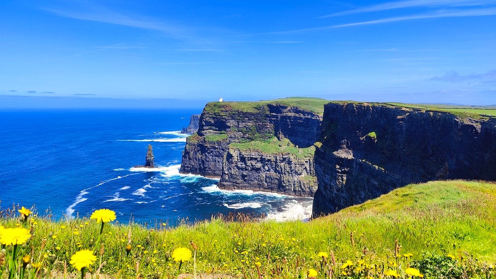
The Cliffs of Moher rise as a wall of dark rock for 8 km above the Atlantic Ocean in County Clare, on Ireland's west coast. At their highest point of 215 m, they are among the country's most visited natural sites and have served as a backdrop for several international film productions.
Why Visit the Cliffs of Moher
The site combines several attractions that justify its place on most Irish itineraries. The sheer vertical drop of the cliffs straight into the Atlantic offers panoramic views across the Burren coast and, on clear days, toward the Connemara to the north. The Aran Islands — Inishmaan, Inishmore, and Inisheer — are visible in the distance offshore.
The cliffs are also a major ornithological site: puffins, choughs, guillemots, petrels, gulls, cormorants, and falcons inhabit the rocky walls, particularly in spring and early summer. The site is also well-known among film enthusiasts: it appears in Harry Potter and the Half-Blood Prince, Asterix & Obelix: God Save Britannia, The Princess Bride, and Leap Year.
History and Geology
The formation of the cliffs dates back to the late Carboniferous period, between 358 and 298 million years ago. The dark rocks composing the wall originated from sediments of mud and sand deposited at the mouth of an ancient river, compacted over millions of years. Marine erosion continues to sculpt the base of the cliffs today, which display their characteristic black tint.
At the summit of the highest point stands O'Brien's Tower, built in 1835 by Sir Cornelius O'Brien as an observation tower for the visitors of that era. It remains the main visual landmark of the site today.
The Legend of Mal and Cu Chulainn
Local folklore attributes to the rock formation known as Hag's Head, at the southern extremity of the site, the silhouette of a woman named Mal. According to tradition, Mal fell in love with the Celtic mythological hero Cu Chulainn and attempted to follow him when he crossed the sea by leaping; she is said to have crashed at the base of the cliffs, giving the rock the shape of her face. This story belongs to folklore and holds no historical value, yet it is still told on site.
What to See and Do
O'Brien's Tower and the Main Path
From the Visitor Centre car park, a paved ramp leads in just a few minutes to O'Brien's Tower, the main viewing point. From here, you can take in the entire expanse of the wall both north and south.
Trails Along the Cliffs
Beyond the developed area, trails run the length of the 8 km of cliffs, northward toward Doolin and southward toward Hag's Head. These paths have no safety barriers: keep a safe distance from the edge, especially in strong winds, and wear appropriate footwear. The sections outside the central zone are considerably less crowded and offer a more contemplative walking experience.
Atlantic Edge and the Visitor Centre
The Atlantic Edge visitor centre, partially built into the landscape to blend with its surroundings, houses an exhibition dedicated to the site's ecosystem and geology, a restaurant with views, and souvenir shops. It also serves as an information point for weather conditions.
When to Visit
The cliffs can be visited year-round, though conditions vary significantly by season. From May to August, days are long and seabird colonies, including puffins, nest on the walls — this is the best period for birdwatching, though tourist numbers are also at their peak.
Spring and early autumn offer a nice balance between daylight, crowds, and weather. In winter, the site remains accessible but winds and showers are frequent, and certain days may be unsafe.
If possible, visit in the morning or late afternoon to avoid the peaks of midday coach tour traffic.
Practical Information
Access to the cliffs is free, but car parking at the Visitor Centre is charged and typically includes access to the exhibition. Allow approximately 1.5 to 3 hours depending on whether you stay near O'Brien's Tower or venture onto the side trails.
The Visitor Centre operates a four-level weather safety system:
- Green: normal conditions, no restrictions.
- Yellow: visit possible with caution, heightened vigilance near the edge.
- Orange: approach to the cliffs not recommended, centre remains open.
- Red: site evacuation.
Check the current code before you depart and adjust your itinerary accordingly. Bring a waterproof and windproof jacket regardless of the season.
How to Get There
The cliffs are located in the southwest of the Burren region. From Galway, allow approximately 1.5 hours driving via the R478. From Doolin, about ten kilometres to the north, access is quick and the village makes a convenient base for combining a visit to the cliffs with a ferry ride to the Aran Islands.
The R478 is heavily trafficked during peak season by both cars and coaches. Secondary roads in the Burren are narrow and bordered by stone walls: drive carefully. Organized excursions departing from Galway, Limerick, or Dublin also serve the site on a daily basis.
Nearby Attractions
The region offers several worthwhile extensions to a visit to the cliffs:
- Doolin, a port village renowned for its traditional music scene and ferries to the Aran Islands.
- The Burren plateau, a unique karstic landscape in Western Europe.
- The lakes and highlands of western Ireland, accessible by extending your route southward.
- Lissadell House and the northwest coast for those with several days available.
Frequently Asked Questions
Frequently asked questions
A typical visit around O'Brien's Tower and the Visitor Centre takes 1.5 to 2 hours. Allow 3 to 4 hours if you wish to walk a substantial section of the side trails.
Access to the site is free. However, car parking at the Visitor Centre is charged and typically includes access to the Atlantic Edge exhibition.
No. Beyond the developed area near the tower, trails run along the cliff edge without barriers. Keep a safe distance from the edge, particularly in strong winds, and follow the Visitor Centre's guidance.
From late April through early August, when colonies nest on the walls. Binoculars are helpful for spotting them.
Yes. The port at Doolin, 10 km to the north, offers seasonal ferries to Inisheer, Inishmaan, and Inishmore. Some excursions combine both sites in a single day.
Planning Your Irish Itinerary
The Cliffs of Moher fit naturally into a west coast tour, between Galway, the Burren, and Connemara. To build a custom journey including this site and other Irish highlights, explore our Ireland trips.
Interested in this visit?
We can include it in your personalised itinerary.