Gweedore
Gweedore, in Donegal, is one of Ireland's most vibrant English-speaking communities. Boglands, Mount Errigal, remote beaches, and traditional music make this an authentic destination far from the beaten path.
Gweedore — An Gaoth Dobhair in Irish — is a Gaelic community in northwest Donegal, bordered by the Atlantic and the foothills of Mount Errigal. It is one of Ireland's most vibrant Irish-speaking zones (Gaeltacht): the language, traditional music, and a landscape of boglands and cliffs make it a unique destination far from mainstream tourist circuits.
Quick facts
- Access: a car is recommended — Gweedore is approximately 75 km northwest of Letterkenny, accessible via the N56 and secondary roads.
- Language: Irish is the daily language; English is understood everywhere.
- Recommended duration: two to three days to combine scenery, music, and coastline.
- Best time to visit: May to September for daylight and hiking conditions.
What to see
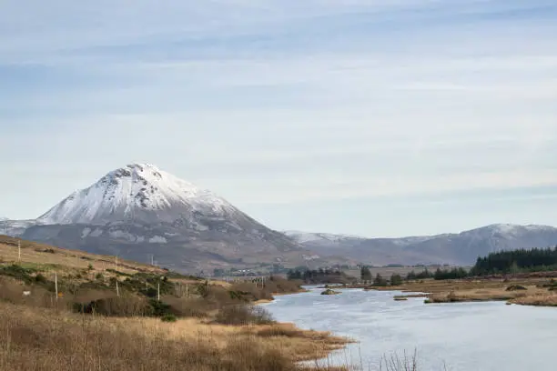
The landscape dominates everything: brown boglands, inland lakes (loughs), nearly deserted white-sand beaches such as Magheraroarty and Derrybeg. Mount Errigal, Donegal's conical peak, rises just to the east and can be climbed in a few hours from the main road. The rugged coastline offers direct views of the Donegal Aran Islands.
History and context
Gweedore endured the Great Famine of the 1840s with considerable loss of life. Landowner John George Adair is associated with the massive evictions of 1861 in the neighbouring region of Derryveagh. Despite this, the community preserved its language and traditions. Today, Gweedore is also known for being the birthplace of the band Clannad and singer Enya, who come from the Brennan family of Gweedore.
Highlights of a visit
Mount Errigal
Donegal's highest peak (751 m), Errigal stands out for its white quartzite silhouette. The climb from the R251 car park is accessible to hikers in good physical condition. The summit panorama encompasses the ocean, Dunlewey and Nacung lakes, and on clear days, the Scottish coast.
Dunlewey Lake and Poisoned Glen valley
At the foot of Errigal, Dunlewey Lake mirrors the surrounding mountains. Poisoned Glen — a steep-walled rocky valley — is accessible on foot from Dunlewey. The name may derive from a toxic plant that grows there, or from a mistranslation of the Irish An Gleann Neimhe ("heavenly glen").
Irish music and culture
The pubs of Bunbeg and Derrybeg regularly host traditional music sessions (seisiún). The region has produced several internationally renowned musicians; musical culture remains vibrant and not staged for tourists.
Beaches and Atlantic coast
The beaches of Magheraroarty, Bunbeg, and Carrickfinn are rarely crowded even in summer. Donegal Airport (Carrickfinn) is one of Europe's most spectacular for its approach between sea and mountain.
Photography tips
Golden-hour light in the morning and evening transforms the boglands into shades of gold and amber. Errigal photographs best from the shores of Nacung Lake, with the reflection in the water. Beaches are most photogenic in overcast weather, when diffuse light reveals the greens and greys of the Atlantic.
Location and access
Gweedore spans several hamlets — Bunbeg, Derrybeg, Carrickfinn, Dunlewey — with no single town centre. A car is essential. Donegal Airport (Carrickfinn) offers flights from Dublin. Letterkenny, the main town in the region, is approximately 75 km to the east. Bus Éireann serves the area from Letterkenny, but frequencies are limited.
Nearby attractions
- Glenveagh National Park — Victorian castle on a lakeside, gardens and red deer, approximately 20 km to the east.
- Slieve League cliffs — among Europe's highest sea cliffs, approximately 60 km to the south.
- Letterkenny — Donegal's main town, a logistical starting point for the region.
- Horn Head — spectacular headland with seabird colonies, approximately 30 km to the northeast.
Frequently asked questions
From May to September, the weather is milder and days are longer. July and August remain the busiest months, but the region does not suffer from tourist overcrowding.
No. English is understood everywhere. A few words in Irish are always appreciated, but are not necessary.
The climb is demanding but requires no mountaineering equipment. A good level of fitness, hiking boots, and a waterproof jacket are essential. The summit is at 751 m altitude.
Bus Éireann connects Letterkenny to the Gweedore area, but frequencies are low. Donegal Airport (Carrickfinn) is located within the municipality itself and offers flights from Dublin. A rental car remains the most practical option.
Yes, the two sites are approximately 20 km apart. One day is enough to visit Glenveagh while staying in Gweedore, by car.
The pubs of Bunbeg and Derrybeg host traditional music sessions, especially in summer and at weekends. Ask locally upon arrival to find out about upcoming sessions.
Want to discover this destination?
Our local advisors design your tailor-made trip.