Dunseverick Castle
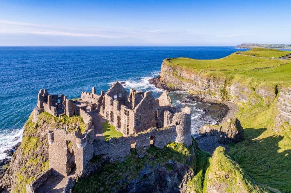
Sixteenth-century ruins on a rocky spur of the Antrim coast, Dunseverick Castle commands raw views over the Irish Sea and integrates naturally into a coastal trail walk.
Perched on a rocky promontory overlooking the Antrim coast, Dunseverick Castle is reduced today to a few stone walls dating from the sixteenth century. What it lacks in height, it gains in setting: sheer cliffs, the Irish Sea stretching to the horizon, and the Causeway Coastal Route passing at its feet. The site is one of Ireland's oldest fortified places, inhabited since the Iron Age.
Practical information at a glance
- Admission: free, outdoor site accessible at all times
- Suggested duration: 20 to 40 minutes on-site, longer if you walk the coastal trail
- Access: car recommended — informal parking along the B146 road at Dunseverick
- Accessibility: rocky and uneven terrain, difficult access for wheelchair users
- What to wear: walking shoes recommended, strong winds frequent
What you'll see
Only a partial tower and a few ruined walls remain, but the location is striking. The castle occupies a rocky spur almost entirely surrounded by sea. On clear days, views extend as far as Scotland. The coastal trail runs alongside the basalt cliffs characteristic of this stretch of coast.
History and context
Dunseverick is mentioned in medieval Irish annals as one of Ireland's great royal forts. The royal road connecting Tara to Dunseverick crossed the entire island. The site is believed to have been fortified as early as the first millennium BC. The structures visible today date from the sixteenth century; the castle was destroyed by Cromwellian forces in the seventeenth century.
Highlights of the visit
The promontory and sea views
The rocky spur offers a direct perspective over the basalt cliffs and, in clear weather, views across to the Scottish coast. It is one of the rawest panoramas on the Antrim coast, without tourist infrastructure.
The coastal trail
The Causeway Coastal Route passes here. Walking east, you reach the Giant's Causeway in under an hour. Heading west, the trail leads to Ballintoy and the Carrick-a-Rede rope bridge.
Photography tips
Morning light from the east illuminates the ruins directly. In late afternoon, the setting sun behind you creates strong contrast between dark stone and sea. Avoid heavy fog days: views of Scotland disappear. Frame wide to include cliffs and sea in the same shot as the ruins.
Location and access
The castle stands on the coastal B146 road, approximately 8 kilometres east of Ballycastle and about fifteen kilometres west of the Giant's Causeway. No regular public transport to the site; car or bicycle remain the most practical options. Parking is informal, along the roadside.
Nearby attractions
- Giant's Causeway — UNESCO World Heritage basalt columns, about fifteen kilometres to the east.
- Carrick-a-Rede rope bridge — suspension bridge above the cliffs, a few kilometres to the west.
- Ballycastle — small coastal town with harbour, shops, and access to Rathlin Island.
- Rathlin Island — inhabited island with puffin colony, accessible by ferry from Ballycastle.
Frequently asked questions
No, the site is free and open to the public at all times. There is no ticket office or on-site staff.
May to September offers long days and better chances of clear skies. In winter, wind and rain make the visit uncomfortable, but the site is quiet and the atmosphere particularly wild.
Yes, the two sites are connected by the coastal trail. On foot, allow about an hour between them. By car, it is about fifteen minutes along the coastal road.
No, the terrain is rocky and uneven. Reaching the ruins requires walking on unstable ground, making it difficult for wheelchair users.
No direct regular service. Car or bicycle are the most practical means. From Ballycastle, some organised tours follow the coast and may include a stop here.
Interested in this visit?
We can include it in your personalised itinerary.